Upper Sanatorium Falls
Description
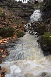
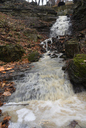
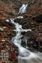
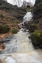
Upper Sanatorium Falls is a 9m high, 3m wide complex ribbon cascade located on a tributary of Chedoke Creek (West branch). It takes its name from the Mountain Sanatorium, which opened above the falls in 1906 to treat patients with tuberculosis.
The watercourse was originally carried under Sanatorium Road through a metal culvert, but this has obviously corroded at some point, to the extent that the watercourse has eroded a new route to the crest of the falls. The remains of the culvert, from which the falls once flowed, can be seen in a number of the photographs below.
Names/Sources ‡
Sanatorium Falls (LOCAL)Upper Sanatorium Falls (CoH)
Media
 | Upper Sanatorium Falls | 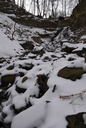 | Upper Sanatorium Falls |
 | Upper Sanatorium Falls | 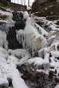 | Upper Sanatorium Falls |
 | Upper Sanatorium Falls | 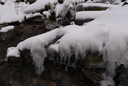 | Upper Sanatorium Falls |
| Location | 79°54'52.927"W 43°14'41.806"N |
| Park | Chedoke Radial Trail |
| Watercourse | Tributary of Chedoke Creek - West Branch |
| Form | Complex Ribbon Cascade |
| Flow | Seasonal |
| Crest Restriction : Access | None : Moderately Easy |
| Foot Restriction : Access | None : Moderately Easy |
| Height : Width (m) | 9.00 : 3.00 |
| Height : Width (ft) | 29 : 9 |
| Authority / Owner | City of Hamilton |