Ridge Falls
Description
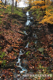
Ridge Falls can be seen on the south side of the railway tracks, 60m east from where they intersect with Dewitt Rd. It is a 7m high ribbon cascade, 2m at its widest. It flows from a culvert fed by ditches that collect runoff from the farmland in the Tapleytown Rd. area above the escarpment.
It is important to always be aware of your surroundings near railway tracks. Do not cross them needlessly. See here.
Names/Sources ‡
Ridge Falls (CoW)Media
 | Ridge Falls |
| Location | 79°42'58.064"W 43°12'25.978"N |
| Park | Vinemount Conservation Area |
| Watercourse | Vinemount/Winona Basin |
| Form | Ribbon Cascade |
| Flow | Seasonal |
| Crest Restriction : Access | None : Unknown |
| Foot Restriction : Access | None : Unknown |
| Height : Width (m) | 15.00 : 2.00 |
| Height : Width (ft) | 49 : 6 |
| Authority / Owner | Hamilton Conservation Authority |